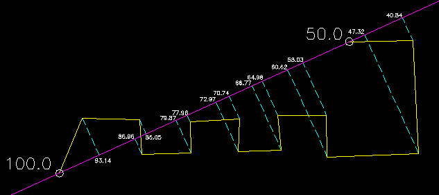
Applies grading to a 3d figure adjusting elevations based on various parameters. All the options below can be applied to the entire figure (all vertices) or you can pick a beginning and ending vertice. All points between the picked points are affected, others are not changed.
Keyboard Command: FigGrdElv
- Elevations: Applies a continuous grade along the specified points based on two entered elevations. The first point takes on the first elevation, the last point takes on the last elevation and all points in between take on a relative elevation based on their distance along the figure.
- Grade: Applies a continuous grade to the vertices based on an entered starting elevation and percent slope. The first vertice will take on the specified elevation, all others will change relative to their cumulative distance along the figure.
- Plane: Builds a plane in memory based on two points with elevations. First specify a start point, you will be prompted for an elevation. Second pick a point that defines the plane direction, you will be prompted for a slope (in percent, like 1.0 = 1.0% slope). The tool then projects all vertices from the figure onto the plane to determine the elevation and updates the figure with those values.
- Project: Applies a continuous grade along the specified points based on two entered elevations. The first point takes on the first elevation, the last point takes on the last elevation. Unlike the elevations option above, the vertex position is projected to an imaginary line between the first and last points and its elevation is derived from the distance along that imaginary line.

In the case above, the beginning elevation of 100.0 and ending elevation of 50.0 is entered. All figure vertices are projected (red dashed) to the imaginary line (green). If a point extends beyond the imaginary line its elevation is still calculated (relative to the imaginary line slope).
- Report: This option first collects a reference list of points in the drawing. It then generates a detailed report along the figure which includes station, elevation, grade, slope, ratio, horz/vert/slope distances and comment. If the figure vertex has the same coordinates as a found point, its point number and description becomes the comment.
Note: The station listed is the distance along the figure and does not represent any station along any alignment.
 Figure Grade Elevations