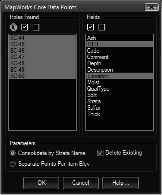
The Data Points routine generates XYZ data points from the borehole data. These data points are placed in separate layers for ease of processing.
Keyboard Command: GeoBorPts

Procedure:
- Select Data Points from the Geology menu.
- Select the holes to process on the list to the left.
- Specify fields to include in the section to the right.
- Choose to begin processing.
Consolidate Notes:
- The layer name used for a point is the strata name and field name separated by an underscore.
- If your data has a large number of strata names and fields, numerous layers will be created.
- Unless you're appending new holes, it's highly recommended that you leave on the Delete Existing Points toggle to prevent duplicates.
Separate Points Notes:
- The resulting points are grouped by geology code name.
- Delete existing does not apply to this option.
 Borehole Data Points