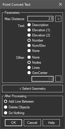
Used to convert text that is often accompanied by point objects or crossing lines to indicate the position. It allows flexibility by designating whether the text is the point number, elevation or description.
Keyboard Command: PntCnvTxt

Procedure:
- Open the drawing containing the text and geometry.
- Initiate the tool from the menu, ribbon or command above.
- Specify whether the found text is the point number, elevation, or description.
- Specify the form the node geometry exists in.
- Pick the button and choose the node geometry.
- Choose the Create Points or Save to File Option.
Notes:
- When using points, inserts, circles or crossing lines:
- The adjacent text will be found, not selected.
- You can speed up the process by creating a separate drawing containing only the text you know qualifies (irrelevant text/mtext in other parts of the drawing can slow down the process).
- If there is a single piece of elevation text, use the Elevation (1) option. In some rare situations the text could be broken in two and placed left/right of a x marker (like 123x45) indicating the point is at the X. In this case, use the Elevation (2) option.
- If the found text is elevation and the text contains spaces and no decimal, the spaces are changed to a decimal to determine the elevation.
- If the text stands alone, the insertion point of the text object is used to obtain the coordinates.
 Point Convert Text