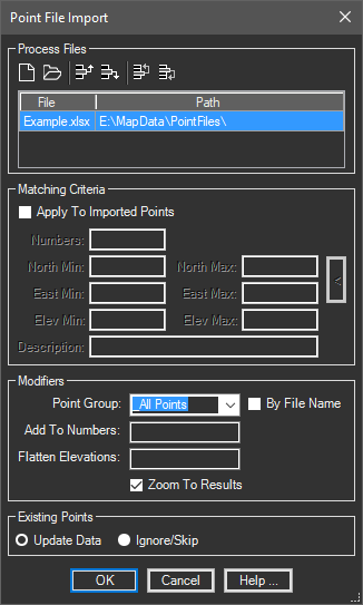
This tool is used to import points into the current drawing from multiple point files.
Keyboard Command: PntFilImp

Section Details:
- Process Files: Used to control the list of files to process. Use the button to add multiple files to the list. The button immediately clears the list.
- Matching Criteria: Can be used to limit the points imported.
- Number Range: A string indicating the number range to import. Separate ranges by dashes and multiple ranges with commas. For example 1-10,20-30 would import points 1 through 10 along with points 20 through 30, ignoring all others.
- Coordinate Range: You can limit import to a rectangular cube by specifying minimum and maximum northing, easting, and elevation values.
- Description: Allows you isolate points that matches a description.
- Modifiers:
- Point Group: Choose a point group from the list or type in a new name for the points to belong to.
- Add to Numbers: Allows you to add an amount to numeric points while being imported.
- Zoom To: If this toggle is on, the viewport will be zoomed to the extents of the newly imported points.
- Flatten Elevations: If a numeric value (such as 0.0) is entered, all points will be assigned this elevation.
- Existing: If the imported file contains a point that exists in the drawings, these options are available.
- Update Data: Updates the point, moving it the new location and updating attributes such as description.
- Ignore/Skip: The point record in the import file is ignored, no changes are made to the existing point.
Format Specific:
| EXT | Description | ||||||||||
|---|---|---|---|---|---|---|---|---|---|---|---|
| XLSx | These conditions must be considered in importing spreadsheet files.
|
 Point File Import