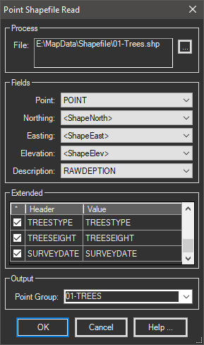
Reads point based shapefiles with options to plot points or export standard coordinate files.
Keyboard Command: PntShpRed

Procedure:
- Use the button to choose the shape file.
- Choose the drop down fields to use for point attributes.
- Toggle on extended fields to include with the points.
- Choose to create the points in the drawing.
Notes:
- The Point <Auto> field should be used when the shapefiles database does not contain a point number column.
- The <ShapeNorth>, <ShapeEast> and <ShapeElev> fields represent the coordinates stored in the actual SHP file. There may be more appropriate data in the corresponding DBF, especially for elevations.
- The default extended field name is the same as the DBF field name (header column, gray). You can override that name by changing it in the Value column. Be aware that long names with special characters could be a problem when exporting back to a ShapeFile.
 Point Shapefile Read