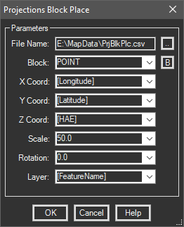
Places inserts into the drawing at projected locations from files containing lat/long values. Additional fields in the file are mapped to block attributes.
Keyboard Command: PrjBlkPlc

Procedure:
- Open the drawing to place inserts into.
- Assign a coordinate system to drawing if necessary.
- Initiate this tool from the ribbon, menu or the command above.
- Click the Select button and choose the data file.
- Choose a block (or field) name from the list.
- For each field, choose a matching field from the table, or type in a value to use for all inserts.
- Designate additional parameters as desired.
- Choose the button to begin placing inserts.
Notes:
- If you don't have a suitable block definition, click the button to build one after choosing the import file. The block build will include all the fields and can be edited later.
- Fields from the external data source are enclosed in square brackets. In other words, the Block field may contain block names contained in the drawing (without brackets) and fields from the data source (with brackets).
- While the dialog allows you type in values for X/Y coordinates, the use of this would be extremely rare. The more logical approach is fields in the external data source used as the coordinates.
- All attributes with tags matching field names in the data source are automatically filled in.
 Projections Block Place