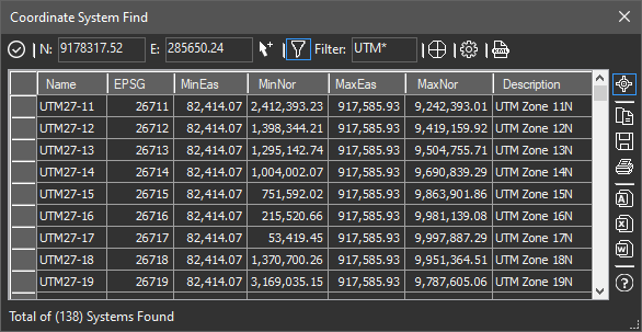
Helps determine a drawing's coordinate system by finding those bounding a selected point or one of additional methods.
Keyboard Command: PrjFndSys
Note: Requires that the current drawing be on proper system coordinates, even though the system name may be unknown.

There are two recommended procedures depending on whether a lat/long of a prominent point is known (best case). For example, if a feature such as a road intersection is shown in the drawing and you are able to find the same location Google Earth (GE). This is considered the best case because the resulting list can be as little as a single system which is often the correct one.
Procedure (Known Lat/Long):
- Open the drawing you wish to determine the system of.
- Zoom the drawing into a prominent feature (such as road intersection).
- Initiate the tool using the menu, ribbon, or command above.
- Use the Pick Point button to pick the prominent point.
- Activate Google Earth and zoom tightly into the same point chosen in the drawing.
- Click the Google Earth Place Pin button and place a pin at the location.
- Right click the newly created pin, choose 'Copy'.
- Back in CAD, confirm the (+) button is selected and lat/long are filled in.
- Enter the distance tolerance (in drawing units FT/M) to allow (lean to larger) values.
- Click the button to begin searching for results, wait for completion.
- Review the smaller list of systems found. If a system qualifies, select the row and click the button.
Procedure (Unknown Lat/Long):
- Open the drawing you wish to determine the system of.
- Initiate the tool using the menu, ribbon, or command above.
- Enter the coordinates to find or use the adjacent pick button.
- Optionally filter the names found with a condition like UTM*.
- Click the button to begin searching for results, wait for completion.
- Optionally click the KML button, creating a KML file to search (see notes).
- Review the systems found. If a system qualifies, select the row and click the button.
Notes:
- If the Point icon on right vertical toolbar is turned on, as you select a row in the grid, an instant update of that GE location appears.
- If you choose to type in the lat/lon coordinates shown in GE, ignore the N/E/S/W characters. However, if you see "W" at the end of the longitude, you will later prefix your longitude with a - sign (for negative longitude). Same logic applies to "S" on latitude.
- The KML file option can be very useful. Assuming the geometry in your drawing was on a proper coordinate system (but no system assigned), zooming and panning to the known location in Google Earth can allow you to quickly locate the proper system visually!
 Projections Find System