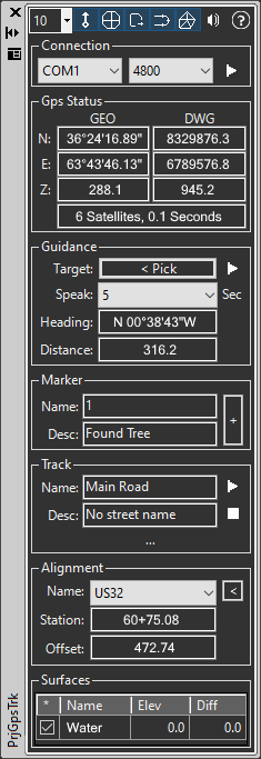
This tool is used to track a GPS receiver and collect data, receive voice guidance and more. The dialog is divided into sections and (nearly) all sections may be hidden if they are not in use. This helps keep the dialog from being too tall and lets you focus on the task at hand.
Keyboard Command: PrjGpsTrk

- Toolbar: Controls the size of the position marker (blue dot) along with the visibility of the sections of the dialog and lastly the status of speech (for guidance).
- Connection: Choose the COM port and baud rate specified by your GPS enabled laptop or tablet, or your add-on receiver.
- GPS Status: This information area shows the current geographical position in lat/long with elevations in meters, along with the projected coordinates in your drawing system. It also shows the number of satellites available on the last read, along with the number of seconds since the read.
- Guidance: First you must pick a target point in the drawing, then click the adjacent button to begin guidance. The same button can be used to stop guidance after it is started. For safety and convenience it is recommended you turn on the speech option for this tool and consider headphones for noisy areas.
- Marker: As you stand near the point, supply an optional point name and description. Then click the adjacent button to add a marker. If the marker name is numeric, its value will be incremented automatically for the next point.
- Track: Move to the beginning point for the track you want to collect. Optionally specify a name and description then click the play button to begin recording points. As you move you will see the number of points increase. You can pause the track at any time to step off the track and collect a point (marker), then return to where you left off and resume.
- Surfaces: As you move, the elevation and vertical difference to surfaces in the drawing are displayed.
Notes:
- Take into account the accuracy of your GPS receiver. Most inexpensive equipment is considered recreational class and can be off by as much as 5 meters (15 feet). More expensive mapping class equipment can be within 1 meter and survey class equipment is very accurate. Check the specifications of your receiver and use the resulting data with care and consideration of that precision.
- In our experience the GPS receiver may take a moment to lock onto the best position. We recommend you start your connection and wait for any point jiggling to settle down before you begin collecting data or using guidance.
- When using Guidance (with speech) the best results are while moving forward. When you first begin and if you stop and turn around during the activity, the results will vary. Begin walking in the direction you assume the target to be, and listen to the angle output.
- Depending on the CAD engine (and version) used the marker may be a GeoPositionMarker or it may be an insert of our supplied block definition.
 GPS Tracking