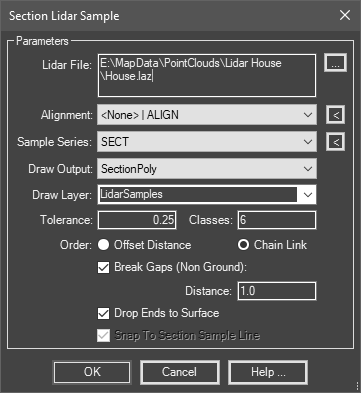
Applies section sample lines to a lidar file to pick up a data band.
Keyboard Command: SecSmpLid

Procedure:
- Open or create a drawing containing an alignment, section sample lines and optional section views.
- Initiate this tool from the menu, ribbon or command above.
- Select the alignment from the dropdown list.
- Select the section series from the dropdown list.
- Choose a draw output option from the list.
- Specify other options as desired.
- Click to begin processing.
Notes:
- The section views must already exist with acceptable ranges for the SectionPoly option to work as it draws on section views.
- The 3dPolyline, Points, and FeatureLine options draw in plan view, so they do not require section views.
- The tolerance is ½ of the corridor width to consider points, or the distance from the sample line to a point to consider. If you use a distance too large, points may be picked up that don't represent the section at that sample.
- The classes field lets you specify multiple classes to draw (e.g. classes 2 and 6 are existing ground and buildings, respectively).
- Classes such as 6 (Buildings) create special situations since the results break (bldg top, gap, bldg top). To accommodate this, turn on the Break Gaps toggle and enter the minimum distance to consider a break (space between buildings). Also, there usually are no points on the ground level with a class like 6 to tie down the building. Turn on the Drop Ends toggle to draw segments from the building top points down to the surface.
 Section Sample Lidar