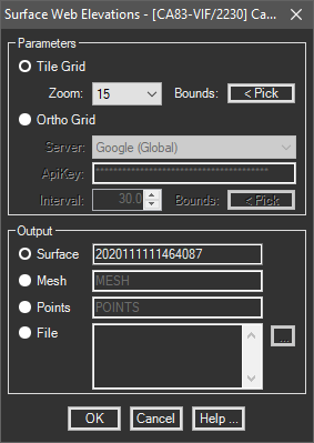
Creates a surface (or insert/export points) on a grid interval with the elevations returned by Bing, Google, MapZen, or the USGS Elevation Service.
Keyboard Command: SurWebElv
There are two methods of generation:
- The first (Tile Grid) uses elevation tiles (grid of points) that are downloaded. Since the points are pre-determined and are in lat/lon coordinates, the results are a TIN or a non-ortho mesh.
- The second (Ortho Grid) collects elevations at points determined by the interval and window you choose and generates an ortho grid. Tile Grid with a zoom of 15 is recommended. This function requires an active Internet connection.

Procedure:
- Open the drawing you plan to generate data in.
- Assign a coordinate system to the drawing if not already done.
- Initiate this tool from the menu, ribbon or command above.
- Choose the method to use (based on information in the first paragraph above).
- Optionally change the elevation web server (if applicable).
- Optionally change the process interval values (if applicable).
- Click the button to designate the process area.
- Confirm the point count is acceptable (if applicable) echoed at the command prompt.
- Designate whether to create a surface, mesh object, create points or a point file.
- Enter additional parameters as needed.
- Choose the button to begin processing.
Server Notes:
| Topic | ApiKey | Attribution | Description |
|---|---|---|---|
| Bing: | Link | Details | Requires an API key. |
| Google: | Link | Details | Requires an API key. |
| Open Elevation: | N/A | Details | Does not require an API key. If you make use of this data, consider donating to the server host (click details). |
| USGS: | N/A | Details | Does not require an API key but is limited to the USA. Because of the slower processing, you may wish to sample a small area to verify results, then run the process in a separate session of CAD. |
Tile Grid:
The source data for the tile grids was aggregated by Mapzen and is hosted by Amazon Web Services. Higher zoom levels provide better results.
 Surface Web Elevations