 Map Import
Imports map files in various formats into the current drawing. Depending on the type of file the results could be points, lines, polylines, 3Dfaces or a combination of these.
Keyboard Command: MapFilImp
Each section of the dialog is explained in detail in the sections that follow.
Dialog Section Details
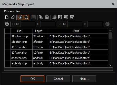
Process Buttons:
- Clear: Clears the list immediately. Save the list before clearing if desired.
- Add: Allows you to add multiple files to the list using a standard Windows multiple file select dialog. When launched for the first time within a session, the dialog will show all supported file formats. Choose the "Files of Type" popdown at the bottom to choose a specific format. This will filter the file list based on the files extension making it easier for you to select files of that type. Once the files are selected and is chosen, the files will be added to the process grid list.
- Ext Data: When this toggle is on, additional information may be added to the imported object. This data can be managed with tools on the Extended Data flyout if it is available (depends on package purchased).
- Zoom Ext: Turn on this toggle to have the display zoom into the newly imported objects after all files have been imported.
- Set System: Sets the coordinate system field for all selected rows. If the current drawing has not been assigned a coordinate system this option will be grayed out.
- Copy: Copies the contents of the process grid to the clipboard ready to be pasted into a spreadsheet (or other) application.
- Save: Saves the contents of the process grid to an external file format.
- Browser: Displays the grid in a browser suitable for printing.
- Table: Generates a CAD table object of the grid data.
- Excel: Exports the grid data to Microsoft Excel (if installed).
- Word: Exports the grid data to Microsoft Word (if installed).
Area Limits:
To limit the import to a rectangular area of interest, click the button to enable the limiter. Then either type in known coordinates or use the window select button at the far right to pick a window. From a projection standpoint, this window is in the target coordinate system. If source files have a different system, this window will be transformed on each file.
Note: When specified, entities that are completely enclosed by and also cross the cited limits will be imported and the processing time may increase dramatically on larger data sets as the routine determines which features should be returned.
Process Grid:
- File: The name of the file, filled in by the add process.
- Layer: The layer on which to place the geometry of the file.
- CrdSys: If you plan on projecting to the drawing coordinate system and know the system of the source file, choose the button to select the system.
- Path: The drive and path of the file, filled in by the add process.
Status Display:
This area shows the overall status of the import, considering the multiple files.
Notes:
- Per the ESRI Shapefile Technical Description, "All filenames adhere to 8.3 naming convention."