 PolyContour Shape Read
Import contours from shapefiles with elevations and optionally layers assigned.
Keyboard Command: PlcShpRed
Procedure:
- Open the drawing to receive the contours.
- Initialize this tool using the menu, ribbon or command above.
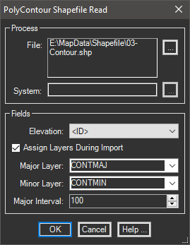
- Click the button to select the ShapeFile to use.
- Choose the elevation field in the dropdown list.
- Optionally specify layering parameters.
- Click to begin processing.
Notes:
- After you select a file, if a coordinate system is detected it will be displayed. You can use the to select a system for the file. The current drawing must have a system assigned for a transformation to occur.
- If you turn off the Assign Layers During Import toggle, all contours will be generated in the current drawing layer.
- Layer names without angle brackets indicate layers already in the drawing, A field with angle brackets can be chosen for the layers also.
- Contours that are a multiple of the Major Interval will be assigned the Major Layer, all others are assigned the Minor Layer.