Establishing a GNSS Base Receiver and Broadcasting RTK Corrections
A practical guide to setting up a GNSS base station, determining its coordinates, and broadcasting RTK corrections using various communication methods such as UHF, spread-spectrum radios, and NTRIP.
-
Purpose of a GNSS Base Receiver
The base receiver in an RTK (Real-Time Kinematic) GNSS setup provides a known reference point from which corrections are transmitted to one or more rovers. These corrections account for satellite, atmospheric, and clock errors common to both the base and rover, allowing the rover to achieve centimeter-level accuracy in real time.
-
Establishing the Base Position
The accuracy of RTK corrections depends on how precisely the base station's position is known. There are three common methods for establishing this coordinate:
-
"Get Here" (Autonomous Position)
In this method, the base simply uses its current single-point GNSS position (computed from one or more measurements) as its reference. This setup is quick and suitable for temporary or relative work where absolute coordinate accuracy is less critical.
- Accuracy: typically 1–3 meters (single-point level).
- Use case: short-term or relative construction work, non-geodetic mapping.
- Limitation: results are internally consistent but offset from true coordinates.
-
Local Coordinate
In a local coordinate setup, the base position is manually entered or derived from a previous survey in a user-defined local system. This is common in construction projects using site calibrations or local grids.
- Accuracy: dependent on previous control or calibration.
- Use case: worksites using a local grid or "site localization."
- Benefit: ensures all measurements are consistent with the project's coordinate frame.
-
Known Coordinate
For high-precision, repeatable, or network-integrated work, the base station is placed over a known geodetic control point, using published coordinates in a recognized reference frame (e.g. NAD83, WGS84, ITRF).
- Accuracy: cm-level or better depending on control quality.
- Use case: permanent base installations, survey-grade mapping, monitoring.
- Benefit: allows consistent absolute positioning and compatibility with other data sources.
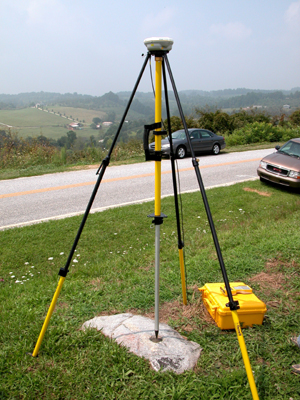
Base receiver mounted over a surveyed control mark — the foundation for RTK accuracy (image courtesy NOAA).
-
-
Broadcasting RTK Corrections
Once the base has a fixed coordinate, it continuously tracks satellites and transmits its correction data to rovers. The data typically follows the RTCM or CMR protocol and can be sent through various communication links:
-
UHF Radio Modem
UHF (Ultra High Frequency) radios are a traditional, robust means of transmitting corrections over distances up to several kilometers, depending on power, terrain, and antenna height.
- Frequency range: typically 400–470 MHz.
- Advantages: independent of Internet or cellular service; low latency.
- Limitations: requires line-of-sight; subject to interference and licensing restrictions.
-
Spread-Spectrum Radio
Spread-spectrum (900 MHz ISM band) radios use unlicensed frequencies and digital modulation techniques to reduce interference. They are often used in construction and agricultural applications for short- to mid-range correction links.
- Frequency range: 902–928 MHz (region dependent).
- Advantages: license-free, easy to configure, moderate range (1–5 km typical).
- Limitations: performance decreases in congested environments.
-
NTRIP (Networked Transport of RTCM via Internet Protocol)
NTRIP transmits RTK corrections over the Internet using a TCP/IP connection between the rover and a caster (server). The base sends its data to the caster as a "mountpoint," and rovers connect over cellular or network data links to receive it.
- Advantages: wide-area coverage, no radio hardware, supports networks of multiple bases (VRS, MAX, iMAX).
- Requirements: mobile data or Internet connection for both base and rover.
- Use case: modern network RTK services or private correction servers.

Example: Bases upload RTCM data to an NTRIP caster; rovers connect via cellular to receive live corrections. -
Other Transmission Methods
- Wi-Fi: Short-range data links for small, localized operations or testing.
- Bluetooth: Typically used for close-range rover–controller communication, not for long-range correction broadcast.
- Cellular Direct Link: Some systems connect directly between base and rover via IP address without a caster.
-
-
Choosing a Broadcast Method
The optimal correction link depends on project environment, available infrastructure, and regulatory conditions:
- Use UHF for remote locations or where reliability and independence from Internet are essential.
- Use Spread-Spectrum for short- to mid-range job sites with unlicensed operation.
- Use NTRIP for large-area or mobile projects with cellular coverage.
Tip: When using radios, always ensure both base and rover radios match in frequency, baud rate, and protocol settings.
-
Verification and Monitoring
After setup, verify the base's broadcast health: